Penang Island is a popular destination in Malaysia and my adventure riding for this year is concluded
with an adventure ride to Penang. After two last-minute withdrawals, Joe and I was the only participant for this ride, later Joe was joined with his wife whom is driving a car to our campsite separately. The plan is to travel using coastal road from
Sabak Bernam to Nibong Tebal before camping in Sungai Batu beach, Teluk Kumbar.
The next day, we will be guided by road less-travelled guru Mr. Teh, around the
island and I will ride alone through E1 back to Rawang.
I started from Rawang alone as Joe will joined me at Sabak
Bernam later that afternoon. I made a move around 7.30am that Saturday morning
heading towards Selangor Fruit Valley plantation and Jalan Rantau Panjang. After
the small bridge, I turned left to Ladang Tennamaram and Jalan Raja Musa.
I was here before when the road is still under
construction.
Then I turned right into Jalan Mawar heading towards Jalan
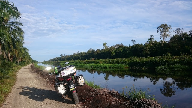
Terusan Utama (Ban Canal). The plantation road has solid gravel surface and the
canal is right at the end of the road.
Ban Canal Waypoint (3km light offroad)
Coordinate N3.42811 E101.25800
The road offers a really breathtaking view and refreshing surrounding with the morning fog is just about to clear when I passed there.
The scenery of paddy field on the left and calm canal water on the right never failed to mesmerize me even after multiple visits to this area.
Then I turned left at Jalan Sungai Panjang (B44) heading
towards Sabak Bernam and Jeti Kilang Sabut. The weather that morning is clear
and the traffic heading to Teluk Intan was light. I continued along Route 5
and later turned left towards Jalan Sungai Air Tawar (B55).
It's low tide at Sungai Bernam when I arrived at Jeti Kilang Sabut around 9.45am.
Jeti Kilang Sabut
Coordinate N3.86630 E100.93341
Joe arrived around 10.13am and we continued to board into a wooden ferry, to across Bernam river from Kampung Sungai Air Tawar to Hutan Melintang.
The ferry is actually a boat modified to transport motorcycles across the river.
The ferry ride lasted about 10 minutes and we rode back up on a wooden jetty, pretty scary for two fully loaded Versys.
We made a quick stop for Petrol at Petronas Hutan Melintang
before continuing towards Kampung Kayan and Trong.
There is a lot of road construction after Sultan Yussof Bridge heading towards Lekir. Riders are advised to be extra careful here as cones and barricades are placed everywehere along this route.
There is a lot of road construction after Sultan Yussof Bridge heading towards Lekir. Riders are advised to be extra careful here as cones and barricades are placed everywehere along this route.
Traffic was quite heavy in Pantai Remis with a lot of tanker
lorries making its way to Changkat Jering. We turned left at Bagan Serai
towards route 75 and Kuala Kurau.
At Kuala Kurau we turn into small road towards Kampung Nelayan and Parit Tiga Puluh. Even with standard exhaust muffler, our bike sound stopped one or two villagers and we returned their smile with a friendly gesture.
We stopped for lunch at a warung serving fresh crabs and shrimps.
At Kuala Kurau we turn into small road towards Kampung Nelayan and Parit Tiga Puluh. Even with standard exhaust muffler, our bike sound stopped one or two villagers and we returned their smile with a friendly gesture.
We stopped for lunch at a warung serving fresh crabs and shrimps.
The place owner said he planned to pack his plastic table
& chair to prepare for the high wave expected later tonight. It is expected
to raise until road level, which is 2 feet above his restaurant floor.
Ban Pecah
Ban Pecah
After lunch, we continued through inner kampong road towards
Ban Pecah and Tanjung Piandang.
The wave’s barrier along the seashore is essential to protect the paddy field in-land. The canal water level is lower than the sea level, which reminds me of the Netherlands!
Ban Pecah
Ban Pecah
Coordinate N5.04428 E100.38347
We head towards Bagan Tiang and Sungai Bakau before turning
left at Parit Kasa to find a shortcut through a small bridge in Teluk Ipil.
The bridge is only passable on 2 or less wheels.
The bridge is only passable on 2 or less wheels.
Small bridge in Teluk Ipil
We arrived
at Sultan Abdul Halim Bridge around 3.15pm. We found out that toll collection
at the bridge is now cashless and lucky my mykad touchngo has RM13.00 in it!
This is the first time we rode on this new Penang’s 2nd bridge
This is the first time we rode on this new Penang’s 2nd bridge
The weather is Batu Kawan is cloudy and it looks like it
will rain very soon but after we crossed the bridge, the weather clears and its
sunshine at the beach when we arrived there around 4.30pm
Campsite Sungai Batu Beach, Teluk Kumbar Penang
N5.27782 E100.24242
From early this week, warnings of high waves and strong
winds are issued so we monitored the sea wave & level situation closely throughout our camping period.
Later that night, Mr. Fazrul & family and Cikgu Misai
from NVOG came to visit us and we chatted through the night.
Thank you Fazrul & Cikgu to accompany us and brought some late snacks with goodie bags.
Thank you Fazrul & Cikgu to accompany us and brought some late snacks with goodie bags.
Joe continued to keep watch on the sea wave situation up
until 3am. By 4pm it began to rain, and it continues to rain until tomorrow
morning. Note the highest water level on the sand with the morning's water level below.
It’s a wet morning on the beach and I have instant noodle and egg for breakfast.
Mr. Teh came as promised around 8.20am and later Ryo came on his KTM. My salute to both of them as they are still willing to continue despite the occasionally heavy rain & strong wind that morning.
It continues to rain even after we finished packing tents and other equipment and we cleared our campsite around 10am.
Penang’s Road Less Travelled
From Teluk Kumbar, Teh brought us up to Bukit Genting, through small orchard trail. It is still raining and we rode slowly and enjoyed the view with occasional mist on the lookup point.
Bukit Genting Hilltop
Coordinate N5.30908 E100.22091
We continue to ride to our second peak, through Balik Pulau and Titi Serong.
When we arrived at Hilton Shelter Hut, the rain continues to pour.
The trail is getting narrower as we headed towards Ngoh Han Hill Temple. Just before one corner my front wheel slipped after crossing a pile of dirt and I tried to brake hard.
That is when my rear wheel locked and slipped. The bike flew left and I jumped to the right, as it’s a steep drop on the left.
Lucky there’s a few trees below the trail shoulder and it stopped my bike from falling even further.
I escaped unscathed and the bike only suffered a broken hand guard and dented side panniers. It takes all four of us pull to get it back on the road and we rested about 5 minutes before continuing towards the temple.
It's all good to continue!
Ngoh Han Hill Temple
Coordinate N5.37659 E100.24389
Facilities: Toilet, lookout point
We descended to Air Itam dam. Riding through the clouds!
Our ride around the island looks like this:
Peak 1 is Bukit Genting and Peak 2 is Ngoh Han Hill. Note the slope (elevation vs distance) on both climbs
The rain has subsided and it began to shine. Teh brought us to Kapitan Tandoori at Lebuh Chulia for lunch.
We said goodbye to Teh & Ryo here and I continued
towards George Town Ferry Terminal.
After waiting slightly over an hour and still haven’t been able to board the ferry, we decided to ride back via Penang first bridge. I said goodbye to Joe here as he is heading back to Langkawi and I am heading to Rawang.
It’s almost 4pm when I passed Juru and 4.30pm when I stopped
for petrol at Bukit Gantang. I met several other bikers heading to KL.
It started raining again here and all the way to Gopeng. I arrived at Rawang around 6pm and the weather is clear after Tanjung Malim.
It started raining again here and all the way to Gopeng. I arrived at Rawang around 6pm and the weather is clear after Tanjung Malim.
I felt grateful and relieved to be able to return safely and
continue this even after the fall. Without the support from Joe,
Teh & Ryo, it would be extremely difficult to recover the bike from the
fall and once again Kawasaki Versys has proven its durability.
As adventure riders we should promote sustainable and
responsible riding. This include how we behave on the road and practice cleanliness,
especially around our campsites. Overall it’s a great adventure riding and a great conclusion
of my adventure calendar this year.
Ride snippets
Rider: Mr. Joe Langkawi & Myself on Versys 650,
(later joined by Teh Soon Kwang on V650 & Ryo Nurshirwan
on KTM 690)
Distance: 790km
Duration: 2 days
Petrol: RM90
Date: 15th - 16th October 2016
Average moving speed: 71km/h
Max elevation: 474m
Lowest temp: 22°C
Highest temp: 37°C


Love this article you posted .
ReplyDeleteWould love to try Seri Tiram Jaya Route .
and the Penang Look Out point you taken .
thank you for sharing this .
~Jat~
another great adventure, i guess those concrete road are not easy yah.....good to see everything ok yah
ReplyDeleteSyabas. Great ride report. Fantastic routing. Detailed and well chronicled. Tq for sharing.
ReplyDelete